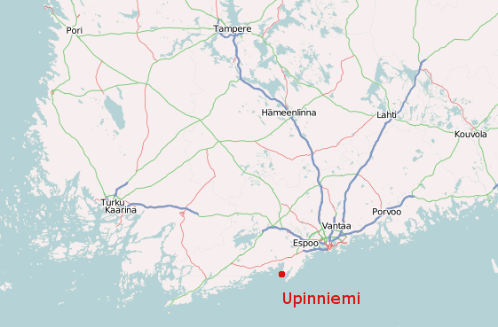
Locations - IPSC Nordic Rifle Championship 2018
Stages 1-7 are located in Syndalen, Hanko and stages 8-14 are located in Upinniemi, Kirkkonummi. The links above point to the location where registration to the match takes place. Also see a simple map of the stages and a GPX file of locations. Travel time between Upinniemi and Syndalen by car during normal traffic is about 70-80 minutes.
Directions to the ranges
Syndalen
The closest street address to match registration desk in Syndalen is Tvärminnentie 850, Hanko. From Helsinki, take the motorway number 51, signed "Hanko". If you are coming from the Helsinki-Vantaa airport, after exiting the airport take the ring III road due west ("länsi") until you come to road 51 and then continue road 51 towards Hanko. At about 70 kilometers from Helsinki, road 51 ends at an intersection to road 25. Turn right to continue on road 25 towards Hanko for about 34 kilometers more and make a left turn towards "Tvärminne". Follow the road for about 3,5 km. Soon after passing an industrial railway level crossing there will be another sign to turn left towards Tvärminne. Drive towards Tvärminne for about 2 km more, when you will have to make again a left turn to a dirt road (at around address Tvärminnentie 850) that goes into a signposted military area. Follow the registration signs ("office").
Upinniemi
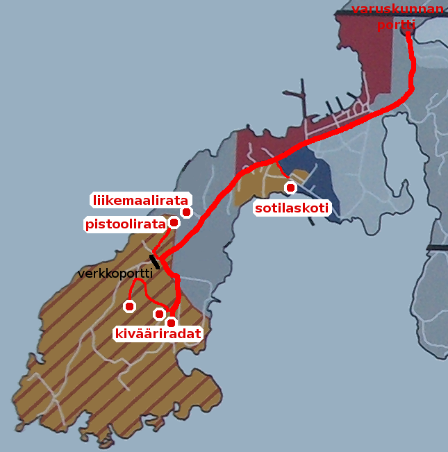
Competitor registration will be at the rifle shooting range number 1 in Upinniemi. There's a green hut next to the shooting shelter. WGS-84 coordinates of the hut are approximately N60° 00.89' E024° 20.42'. Upinniemi garrison gate is located at around address Upinniementie 1060, Kirkkonummi. The gate's WGS-84 coordinates are N60° 02.20' E024° 22.14'.
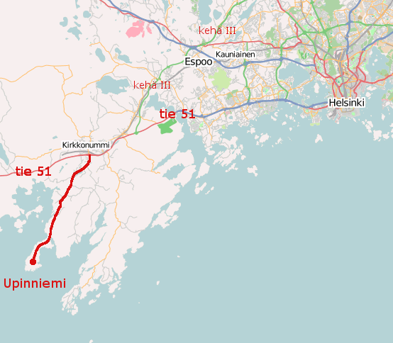
From Helsinki, take the motorway number 51, signed "Hanko". If you are coming from the Helsinki-Vantaa airport, after exiting the airport take the ring III road due west ("länsi") until you come to road 51 and then continue road 51 towards Hanko. At about 27 kilometers from Helsinki take the exit number 18 signed "Upinniemi" and follow the signs to Upinniemi, road number 1191. After driving about 10 kilometers on the road to Upinniemi, you will be at the garrison gate.
Finnish citizens registered into the match and other Finns who have contacted the match director beforehand, will get through the garrison gate (right side lane, labeled "vieraat") by showing the guard a photographic identification document, and by telling him/her that you are coming to an IPSC match organized by Porkkalan Ampujat.
Vehicles with non-Finnish citizens need to pull up to the parking lot immediately before the garrison gate on the right side and wait for the host to let you inside the area.
After passing the garrison gate, stay on the same road for about 3 kilometers more, until a metal mesh gate blocks your way. Turn left just before the gate and continue onwards about 200 meters. Then turn right to a dirt road, signed "Ampumaradat". When the dirt road branches the first time, take the right branch. Then on the next branch, take the left branch, signed "Ampumarata 1". Now find yourself a parking spot. There is very little room for parking on many of the shooting ranges, so please carpool with fellow shooters. Due to longish distances between the ranges, a car is necessary for movement between certain stages.
There is no public transportation to Upinniemi on Sunday mornings. A few trains stop at Kirkkonummi center in the morning, but no buses go to Upinniemi that early in the morning. If you need transportation from the Kirkkonummi train station to the ranges, contact the match director and we'll see what we can do.
Map images
Southern Finland (Helsinki center is just east of Espoo and south of Vantaa):
Western capital area, road to Upinniemi (Upinniementie) drawn on thick red:
Route to registration desk drawn on thick red from the garrison gate:
Two first map images are courtesy of OpenStreetMap, the last one is from an info sign ouside the garrison gate.
Page last modified on Thursday, July 5th, 2018 at 21:18.
